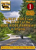
#1 Great Rides Near the Start of the Blue Ridge Parkway
 On This Map: Map #1
- First 40 miles of the Blue Ridge Parkway
- Closest gas station to each parkway exit listed
- More than 20 of the best rides in the surrounding area highlighted and described
- More than 16 good connecting roads shown
- Scenic points, waterfalls, motorcycle-friendly stops, etc. shown
- Map #1 in the 6 Map Blue Ridge Parkway Set
- Remotely located (out-of-town) gas stations identified
- Handy, easy-to-use, accessible pocket map size
- Waterproof and durable
- Best rides boldly highlighted in red
- Good connecting roads highlighted in blue
- Rides are described on back of map
- Mileage between road segments shown
- Overlaps and connects with adjacent maps
 Description of area:
The Blue Ridge Parkway starts it's 469 mile long course south from Virginia's Skyline Drive through Shenanoah National Park in Waynesboro, VA. The Blue Ridge Parkway is a linear park connecting Shenanoah National Park in Virginia to Great Smoky Mountains National Park in North Carolina and Tennessee. The uninterrupted two lane winding National Roadway follows the highest mountain ridges from end to end with spectacular views and historic attractions.
To the east of the park road the vast expanse of the Piedmont rolls towards the coast. To the west the Shenadoah Valley spreads to reach the mountains which rise again near the West Virginia border. As much of this area is broad and relatviely flat, finding the best rides here can be a challenge, but this map will lead you to them.
The roads which intersect this narrow section of the Blue Ridge Parkway tend to be short and steep descents. The best of these are highlighted in red and there are some gems.
You'll also find a good number of connector roads on this map highlighted in blue to help lead you between the best rides and choose the better roads. The rides get better as you head west and the mountains grow. Sometimes it's worth just a few more minutes ride over a ridge to reach the better route in the next valley.
Features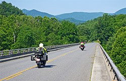
- Explores the best roads of the north central mountains of Virginia
- It dips one corner into West Virginia
- The map touches the suburbs of Lynchburg
- Douthat State Park
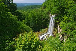
- Falling Spring Falls
- Natural Bridge Attractions
- Peaks of Otter Parkway Visitor Center
- James River Parkway Visitor Center
- Humpback Rocks Parkway Visitor Center
Cities and Towns on this map:
Virginia: Staunton, Waynesboro, Lynchburg, Craigsville, Goshen, Covington, Lexington, Clifton Forge, Iron Gate, Glasgow, Buena Vista, Amhurst, Fincastle, Buchanan
Map Specifics: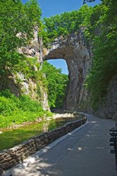
- size (unfolded) - 11 x 17 inches
- Size (folded) - 4 1/4 x 5 1/2 inches (fits in your pocket)
- Fast, simple, easy folding
- Layout - Full color map on one side with detailed directions on the back
- 275+ miles of the best rides are indicated in red
- 80+ miles of good roads to use as connecting rides shown in blue
- Easy to read color-coded road labels to aid navigation
- Mileage between roads is indicated
- Reliable and remote gas stations are shown and those fuel stops nearest the parkway
- Points of interest included
- Roads which connect to the parkway are clearly identified
Know Your Blue Ridge Map Options:
- Map #1 is sold a a single map
-
Map #1 is part of the 6 Map "Blue Ridge Parkway " Map set (Maps 1-6)
-
Map #1 is part of the 7 Map "Blue Ridge Parkway PLUS the Dragon " Map set (Maps 1-7)
-
Map #1 is part of the 9 Map "Full Southeast Package " Map set (Maps 1-9)
