#3 North Carolina / Virginia Border Rides
On This Map:
- Closest gas station to each parkway exit listed
- 400 miles of the best routes shown
- More than 100 Miles of the Blue Ridge Parkway detailed
- More than 40 Great Rides in the surrounding area highlighted
- Scenic points, motorcycle-friendly stops, etc. shown
- Map #3 in the 6 Map Blue Ridge Parkway Set
- Remotely located (out-of-town) gas stations identified
- Handy, easy-to-use, accessible pocket map size
- Waterproof and durable
- Best rides boldly highlighted in red
- Good connecting roads highlighted in blue
- Rides are described on back of map
-
Mileage between road segments shown
- Overlaps and connects with adjacent maps
Description of area: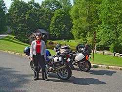
I NEVER expected to find so many great roads in this area! Explore an amazing wealth of two lane back roads which connect to and lie in the areas which surround the Blue Ridge Parkway as it traverses the borders of North Carolina and Virginia. They weave a web of wonderful rides through this rolling terrain. No other map of the region details as many great motorcycle rides as this one. It has become one of my favorite areas to ride in.
The rolling hill country of southern Virginia is full of fantastic scenic two lane roads that wind though the pastoral countryside and into North Carolina. Though the elevations are not as high as found elsewhere, there are plenty of long range views as well as great rides through forests, farmlands and historic sightsdot the landscape. This is where the Blue Ridge Parkway was started and while there is more encroachment from the surrounding neighborhoods, don't be fooled by the views from the park. They are often better once you stray off it into the surrounding areas. I used to lay over further south. Now, I head here, it's just that good!
The Blue Ridge Parkway changes course in this area running more east-west than it's usual north-south diagonal up the spine of the mountains as it makes the connection between the Blue Ridge Mountains of Virgina and the vaulty Black Mountain range in North Carolina. This motorcycle map is the most extensive and detailed compilation of these great roads, many of which intersect the Blue Ridge Parkway, some so obscure they are rarely discovered and enjoyed. Others, more well known, include scenic overlooks and views of stunning mountain parks. I've really enoyed riding this area and producing this map, and I'm sure you will too.
Features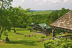
- More than 100 miles of the Blue Ridge Parkway
- Mt Rogers National Recreation Area
- Stone Mountain State Park
- Hanging Rock State Park
- Pilot Mountain State Park
- Shot Tower Historic State Park
- Numerous scenic locations and historic sights
- Chateau Morrisette Winery
- Hungry Mother State Park
- Mabry Mill
- Fancy Gap
- Mt. Jefferson State Park
- Groundhog Mountain
- Rocky Knob
- Meadows of Dan
- Lover's Leap
Cities and Towns on this map:
Virginia: Marion, Atkins, Rural Retreat, Wytheville, Galax, Hillsville, Independence, Stuart, Floyd, Meadows of Dan
North Carolina: Jefferson, West Jeferson, Sparta, Dobson, White Plains, Mt Airy, Pilot Mountain, Danbury
Map Specifics: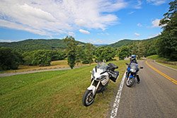
- Size (unfolded) - 11 x 17 inches
- Size (folded) - 4 1/4 x 5 1/2 inches
- Fast, simple, easy folding
- Layout - Full color map on one side with detailed directions and on the back
- Several good connecting roads are shown in blue
- Easy to read color-coded road labels to aid navigation
- Mileage between roads is indicated
- Reliable and remote gas stations are shown
- Numerous points of interest
Know Your Blue Ridge Map Options:
- Map #3 is sold a a single map
-
Map #3 is part of the 6 Map "Blue Ridge Parkway " Map set (Maps 1-6)
-
Map #3 is part of the 7 Map "Blue Ridge Parkway PLUS the Dragon " Map set (Maps 1-7)
-
Map #3 is part of the 9 Map "Full Southeast Package " Map set (Maps 1-9)
- Map #3 is sold a a single map
-
Map #3 is part of the 6 Map "Blue Ridge Parkway " Map set (Maps 1-6)
-
Map #3 is part of the 7 Map "Blue Ridge Parkway PLUS the Dragon " Map set (Maps 1-7)
-
Map #3 is part of the 9 Map "Full Southeast Package " Map set (Maps 1-9)
