#9 The Best Rides in the North Georgia Mountains
 10/6/2019 - New Version Released
- More area covered, more roads, more attractions.
On This Map
- Nearly 300 Miles of Great Rides highlighted
- 30+ Best Rides
- 20+ Good Connecting rides
- Scenic points, waterfalls, motorcycle-friendly stops, etc. shown
- Remotely located (out-of-town) gas stations identified
- Handy, easy-to-use, accessible pocket map size
- Waterproof and durable
- Best rides boldly highlighted in red
- Good connecting roads highlighted in blue
- Rides are described on back of map
-
Mileage between road segments shown
- Overlaps and connects with adjacent maps
Description of area: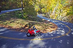
The Appalachian Mountains either begin or end in north Georgia depending on your point of reference. While this southernmost portion does not hold the higher peaks found further north in the Smoky Mountains, these Georgia Mountains are the beginnings of the great ranges which span the east coast. This north Georgia mountains motorcycle pocket map opens the door to the great motorcycle ridingwhich starts here and continues throughout the Appalachian chain. I've produced the most complete collection of the best of these great motorcycle rides, some well known, others which are rarely discovered. No other map details as many great Georgia motorcycle rides as this one, puts them in a useful and handy pocket map format, and includes the details you need to explore with confidence.
More than 25 routes are described on this motorcycle map, some of which consist of several great roads linked together. Many of these great motorcycle rides intersect with options to make loop rides. Good connector roads for bikers are highlighted in blue - these motorcycle roads almost made the best of the best roads grade, but either lacked the scenery of the best rides or the challenging and fun curves and turns of a great motorcycle ride. Blue roads help you avoid more traveled main arteriesand are good options when weekend or holiday traffic clogs the main roads. They link together the best motorcycle rides in Georgia and make short cuts between them, detour you around towns, and avoid traffic congestion. This motorcycle pocket map is truly the most comprehensive and detailed compilation of the best motorcycle routes in North Georgia.
This motorcycle map covers the heart of the most mountainous area in the Georgia. It extends across the border into North Carolina, and clips small sections of Tennessee and South Carolina revealing nearly 300 miles of great motorcycle riding adventures.
Features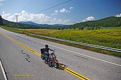
- More than 25 different routes described
- Nearly 200 miles of the best roads are highlighted in red
- 75 miles of good connector roads are highlighted in blue
- All the best roads east of US 515 and west of US 441
- Several state parks,
- Chattahoochee National Forest
- reservoirs and dams
Cities and Towns on this map:
Georgia: Dahlonega, Cleveland, Demorest, East Ellijay, Blue Ridge, Morganton, Mineral Bluff, McCaysville, Blairsville, Young Harris, Hiawassee, Helen, Tallulah Falls, Mountain City, Dillard, Clayton, Cornelia, Toccoa, Clarkesville, Tiger, Turners Corner, Suches, Porter Springs, Ivy Log
Tennessee: Ducktown
North Carolina: Murphy and Hayesville
Map Specifics: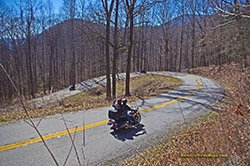
- Size (unfolded) - 11 x 17 inches
- Size (folded) - 4 1/4 x 5 1/2 inches
- Fast, simple, easy folding
- Layout - Full color map on one side with detailed directions on the back
- Nearly 200 miles of the best routes are indicated in red
- Easy to read color-coded road labels to aid navigation
- Mileage between roads is indicated
- Reliable and remote gas stations are shown
- Numerous points of interest
- Dealer / Repair facilities shown
Know your Blue Ridge Map Options: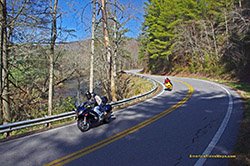
- Map #9 is sold a a single map
- Map #9 is part of the 9 Map "Full Southeast Package " Map set (Maps 1-9)
