Smoky Park Series - 3 Maps
$23.97
$19.99
Free Shipping!
3 Maps Cover the amazing number of great rides near Great Smoky Mountains National Park
If you plan to spend time riding in and around Great Smoky Mountains National Park, these are the 3 maps for you. They help you avoid the traffic on the north side of the park, lead you to the Dragon at Deals Gap and the Cherohala Skyway on the west side, show the best section of the Blue Ridge Parkway to the east, and the Land of the Waterfalls to the south.
The Smoky Mountains are the hub of the best riding in the Blue Ridge. With more than 40 Mountains over 6000 ft in elevation in this area you'll be traveling some of the most scenic roads you'll find anywhere.
Also shown / additional features: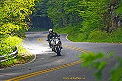
- Pocket maps 6-7-8
- Nearest Gas Station to each Blue Ridge Parkway exit listed
- Remotely located (out-of-town) gas stations identified
- Handy, easy-to-use, accessible pocket map size
- Waterproof and durable
- Best rides boldly highlighted in red
- Good connecting roads highlighted in blue
- Rides are described on back of map
-
Mileage between road segments shown
- Find riding in VA,NC,SC, TN, GA
- Scenic points, waterfalls, motorcycle-friendly stops, etc. shown
- Maps overlap and connects with adjacent map
Map Options: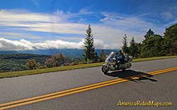
America Rides Maps cover this Smoky Mountains area in several ways -
-
3 Pocket maps - #6, #7, #8
-
Premium Map - 100 Motorcycle Rides Near Smoky Park
- 12 Classic Deals Gap Motorcycle Rides covers the same area.
Know Your Blue Ridge Map Options:
- 3 map "Smoky Park" Map set (Maps 6-8)
- 6 Map "Blue Ridge Parkway " Map set (Maps 1-6)
- 7 Map "Blue Ridge Parkway PLUS the Dragon " Map set (Maps 1-7)
- 9 Map "Full Southeast Package " Map set (Maps 1-9)
